السبت، ٢٨ فبراير ٢٠٠٩

Krooki to Google Maps - UTM to Degrees

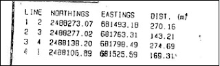
Following to a previous tool I have developed to convert data projection from Clark 1880 to WGS84 and as a request from many viewers to develope similar tool in Google Maps. I am Happy to announce the birth of Krooki to Google Maps application. This application allows input using x, y coordinates or what called UTM coordinates (Northing, Easting) directly from the krooki and then it converts the coordinates to degrees which are acceptable by Google Maps and it will locate the plots coordinates on Google Satellite maps. This conversion is accurate in Oman only as its uses Zone 40 parameters

Krooki to Google Maps V1.1

الاثنين، ٣١ مارس ٢٠٠٨

ArcMap and Google Earth Integration


The movie below shows how to build a tool in ArcMap that will sycronize the current ArcMap extent with Google Earth extent this code is working with wg84 projections. To use this code you should have GE installed on your PC


copy the code below to a mousedown event on UIToolControl on ArcMap VBA

Dim pScreenDisplay As IScreenDisplay
Dim pActiveView As IActiveView
Dim pMxDoc As IMxDocument

Set pMxDoc = Application.Document
Set pActiveView = pMxDoc.FocusMap
Set pScreenDisplay = pActiveView.ScreenDisplay
pScreenDisplay.TrackPan

Dim pMap As IMap
Dim pMapsActiveView As IActiveView
Dim pEnvelope As IEnvelope
Dim pCenterPt As IPoint
Dim pEnvSpatRef As ISpatialReference
Dim pSRI As ISpatialReferenceInfo
Dim pPCS As IProjectedCoordinateSystem
Dim dMetersPerUnit As Double
Dim viewAlt As Double

'Google Earth Parameters

Dim GE As IApplicationGE
Set GE = New ApplicationGE

'Set the ArcMap values
Set pMxDoc = Application.Document
Set pMap = pMxDoc.FocusMap
Set pMapsActiveView = pMap
Set pEnvelope = pMapsActiveView.Extent
Set pCenterPt = New Point
Set pEnvSpatRef = pEnvelope.SpatialReference

'Get current meters per map unit
If pEnvSpatRef Is Nothing Then
MsgBox "Please set a projection for your Map", vbOKOnly, "No Projection Set"
Exit Sub
ElseIf TypeOf pEnvSpatRef Is IUnknownCoordinateSystem Then
MsgBox "Please set a projection for your Map", vbOKOnly, "Projection Unknown"
Exit Sub
ElseIf TypeOf pEnvSpatRef Is IProjectedCoordinateSystem Then
Set pPCS = pEnvSpatRef
dMetersPerUnit = pPCS.CoordinateUnit.MetersPerUnit
Else
dMetersPerUnit = 1
End If

'Set view altitude the same as the width (seems to zoom enough)
'Get width, then convert it to meters using the metersperunit value
viewAlt = Round((pEnvelope.LowerRight.x - pEnvelope.LowerLeft.x) * dMetersPerUnit)

'Create a WGS84 spatial reference for LatLong in Google
Dim pSpRef2 As ISpatialReference
Dim pSpRFc As SpatialReferenceEnvironment
Dim pGCS As IGeographicCoordinateSystem
Set pSpRFc = New SpatialReferenceEnvironment
Set pGCS = pSpRFc.CreateGeographicCoordinateSystem(esriSRGeoCS_WGS1984)
Set pSpRef2 = pGCS
pSpRef2.SetFalseOriginAndUnits -180, -90, 1000000

'Project the envelope to WGS84
pEnvelope.Project pSpRef2

'Get the Center Point: ((XMin + XMax) / 2, (YMin + YMax) / 2)
pCenterPt.PutCoords (pEnvelope.LowerLeft.x + pEnvelope.LowerRight.x) / 2, _
(pEnvelope.LowerLeft.y + pEnvelope.UpperRight.y) / 2

'Send the parameters to Google
'Note: The altitude mode - RelativeToGroundAltitudeGE = 1, AbsoluteAltitudeGE = 2
'If set the speed to 5 or more it snaps to the site (no transition), a lower number
'(i.e. 3.5) helps show movement has taken place

While (GE.IsInitialized = 0)
'In theory this waits for Google Earth to load if it isn't open already
Wend
GE.SetCameraParams pCenterPt.y, pCenterPt.x, 0, 1, viewAlt, 0, 0.01, 3.5

You can find this tool in http://arcscripts.esri.com/ i have added some minor coding to allow this tool to work with mousedown event.

All the best


الثلاثاء، ٢٠ نوفمبر ٢٠٠٧

Sultan Qaboos Grand Mosque 3D model in Google Earth

Sulatan Qaboos Grand Mosque 3D Model


I have managed to create a model of Sultan Qaboos Grand Mosque in Muscat. The tools I used are Google Sketchup, photoshop and google earth.


The above image shows a snap shot from google sketchup. I had some diffculties on creating the dome, google sketchup free version does not have a tool to create ready made Balls model, but I managed to bring somebody else Manarah and with some small edits I created the above Model.

This model then imported to google earth, (picture below)


I hope you like it, you can download this model by clicking the link below

http://bbs.keyhole.com/ubb/download.php?Number=1056018

you should have google earth installed with you.


الأحد، ٥ أغسطس ٢٠٠٧

حركة جوجلية


لا تعليق
!!!!

أقرب ما يمكن وفي وسط الصحراء

أقرب ما يمكن أن تراه في جوجل ماب الصورة في الأعلى توضح مجموعة من الرعاة يحاولون اخراج الماء من البئر لسقي الجمال
ستلاحظ ايضا البعض منهم ينظرون الى الأعلى. أعتقد أن هذه الصورة التقطت عن طريق طائرة وليس عن طريق قمر صناعي وهذا يفسر النظر الى الاعلى لأنهم سمعوا الضجة التي تحدثها الطائرة
حركات جغرافية

السبت، ٤ أغسطس ٢٠٠٧

تحديد القبلة على الجوجل ماب


يمكنك تحديد القبلة والتأكد من صحتها لأي مسجد كان عن طريق الموقع التالي


والصورة التالية تبين اتجاه القبلة لمسجد السلطان قابوس الاكبر


ماذا سيحدث لمسقط أذا ارتفع منسوب البحر الى اكثر من 8 امتار

الخارطة في الوصلة التالية توضح ماذا سيحل اذا ارتفع منسوب البحر الى ما فوق 8 أمتار


الأحد، ٢٩ يوليو ٢٠٠٧


سلطنة عمان

تحويل قطعة أرض من الكروكي الى برنامج جوجل ايرث

الخطوات المتبعة
-----------------------------
الخطوة الأولى

في البداية يجب تحويل الاحداثيات الموجودة على الكروكي من اسقاط
Clark 80

WGS 84 الى اسقاط

Clark 80 وذلك لأن وزارة الاسكان تستخدم اسقاط
WGS 84 والنظام على جوجل ايرث يستخدم
كمثال نأخذ الصورة التالية من كروكي


Northing لكي تحول بين الاسقاطين ما عليك الا ان تضيف قيمة 249.385 الى الاحداثيات الصادية


Easting وقيمة 289.588 الى الاحاثيات السينية
مثال:

من الصورة اعلاه, النقطة 2488273.07, 681493.18

2488273.07 + 249.385 , 681493.18 + 289.588 تصبح
يعني
2488522.455, 681782.768

---------------------------------------------------
الخطوة الثانية


UTM Flayer اذهب الى الرابط التالي ونزل برنامج


http://www.zonums.com/utmflyer.html

اختر

Zone 40

لان محافظة مسقط تقع على

Zone 40

ضع الاحداثيات

Easting, Northing

الناتجة من الخطوة الاولى في الخانتين

Easting, Northing

انسخ الارقام التي تظهر على خانة

Lat/Lon

وألصقاها في خانة البحث في جوجل ايرث

وغير قيمة

Lon

من سالب الى موجب هذه الخطوة اساسية

اعد نفس الخطوة للنقاط الاخرى في الكروكي قد تحتاج الى اربع نقاط لكي تظهر معالم القطعة